

Coastline of the Cuban archipelago: a vector model for environmental thematic mapping
Article Sidebar
Main Article Content
Abstract
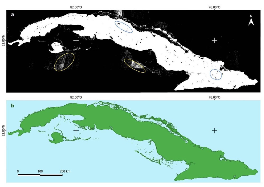
An updated vector model of the coastline of the Republic of Cuba is presented, designed to improve the accuracy and compatibility of thematic environmental mapping. Using high-resolution satellite data (European Space Agency, Sentinel-2) and geospatial processing techniques, a detailed representation (1:25000) is generated, enabling applications in coastal management, ecological conservation, and land use planning. The vector analysis (with 94% overall accuracy) provides an estimate of the Cuban archipelago’s surface area (109887.43 km2) very similar to the country’s official figure. However, the estimated length of Cuba’s coastline (8517.67 km) differs from the 5746 km reported by the National Office of Statistics and Information for over a decade.
Downloads
Article Details

This work is licensed under a Creative Commons Attribution-NonCommercial 4.0 International License.
Those authors who have publications with this journal accept the following terms of the License Attribution-NonCommercial-ShareAlike 4.0 International (CC BY-NC-SA 4.0):
You are free to:
- Share — copy and redistribute the material in any medium or format
- Adapt — remix, transform, and build upon the material
- The licensor cannot revoke these freedoms as long as you follow the license terms.
Under the following terms:
- Attribution — You must give appropriate credit , provide a link to the license, and indicate if changes were made . You may do so in any reasonable manner, but not in any way that suggests the licensor endorses you or your use.
- NonCommercial — You may not use the material for commercial purposes .
- ShareAlike — If you remix, transform, or build upon the material, you must distribute your contributions under the same license as the original.
- No additional restrictions — You may not apply legal terms or technological measures that legally restrict others from doing anything the license permits.
How to Cite
References
Aké Turriza, K.A. & Rivera Arriaga, E. (2024). Análisis del Manejo Integrado Costero en Cuba. JAINA Costas y Mares ante el Cambio Climático, Vol esp (1): 83-96. https://doi.org/10.26359/52462.0824
Álvarez, M. & González, D. (2019). Uso de imágenes satelitales Sentinel-2 para la delimitación costera en Cuba. Revista Geomática Latinoamericana, 17(3), 88-102.
Castellanos González, J. R., Velázquez Labrada, Y. R. & Pérez Benítez, M. (2023). Variación de la línea de costa en playas de Santiago de Cuba. Orange Journal, 5(9), 4-15. https://doi.org/10.46502/issn.2710-995X/2023.9.01
Cardille, Jeffrey A., Crowley, Morgan A., Saah, David & Clinton, Nicholas E. Cloud-Based Remote Sensing with Google Earth Engine. 2024. https://doi.org/10.1007/978-3-031-26588-4
Cohen, J. (1960). A coefficient of agreement for nominal scales. Educational and Psychological Measurement, 20(1), 37-46. https://doi.org/10.1177/001316446002000104
Choung, Y.-J. & Jo, M.-H. (2017). Comparison between a Machine-Learning-Based Method and a Water-Index-Based Method for Shoreline Mapping Using a High-Resolution Satellite Image Acquired in Hwado Island, South Korea. Journal of Sensors, 2017, 13. https://doi.org/10.1155/2017/8245204
Choung, Y. J. (2015). Mapping 3D Shorelines Using KOMPSAT-2 Imagery and Airborne Lidar Data. Journal of the Korean Society of Surveying, Geodesy, Photogrammetry and Cartography, 33(1), 23-30.
Cubadebate. (2023, septiembre 29). Bojeo a Cuba: Uno de los más importantes proyectos de las ciencias marinas de los últimos años. http://www.cubadebate.cu/noticias/2023/09/29/bojeo-a-cuba-uno-de -los-mas-importantes-proyectos-de-las-ciencias-marinas-de-los-ultimos-anos/
European Space Agency. (2025). Sentinel Online. from https://Sentinel.esa.int/web/Sentinel/home
Feyisa, G. L., Meilby, H., Fensholt, R., Proud, S. R. (2014). Automated Water Extraction Index: A new technique for surface water mapping using Landsat imagery, Remote Sensing of Environment, Vol. 140, 23-35. https://doi.org/10.1016/j.rse.2013.08.029.
Instituto Cubano de Geodesia y Cartografía (ICGC) & Instituto de Geografía de la Academia de Ciencias de Cuba (IG-ACC). (1989). Mapas generales y de referencia. En Nuevo Atlas Nacional de Cuba. La Habana. 232 p.
Instituto de Geografía Tropical (IGT). (2020). Atlas Nacional de Cuba LX_2020. La Habana. 140 p
Iturralde Vinent, M. A. (2013). Tipología y evolución de las zonas costeras de Cuba. RedCiencia. http://www.redciencia.cu/geobiblio/paper/2013_iturralde_tipologia%20zonas%20costeras.pdf
Iturralde-Vinent, M. A. & Serrano Méndez, H. (2015). Peligros y vulnerabilidades de la zona marino-costera de Cuba: Estado actual y perspectivas ante el cambio climático hasta el 2100. Editorial Academia.
Maglione, P., Parente, C. & Vallario, A. (2014). Coastline extraction using high resolution WorldView-2 satellite imagery. European Journal of Remote Sensing, 47(1), 685-699.
Martínez Serrano, A. (2010). Descripción cartográfica de los procesos de erosión en la línea de costa y los cambios en la cobertura vegetal, a partir de fotos aéreas e imágenes de satélite Google Earth pro en el asentamiento "Playa del Cajío". Ciencias de la Tierra y el Espacio, 11, 34-46.
Martínez, R. & Suárez, J. (2021). Evaluación de la vulnerabilidad costera en el litoral sur de Cuba mediante SIG. Revista Cubana de Geografía, 30(1), 55-70.
McFeeters, S. K. (1996). The use of the normalized difference water index (NDWI) in the delineation of open water features. International Journal of Remote Sensing, 17 (7), 1425-1432. https://doi.org/10.1080/0143116960894871
Mitrani Arenal, I. (2006). Las inundaciones costeras en Cuba y su repercusión social. Bioética (La Habana), 6(3), 4-12. http://cbioetica.org/revista/63/630410.pdf
Moore, L. J. (2000). Shoreline mapping techniques. Journal of coastal research, 111-124.
Norma Cubana (1984). Geodesia y cartografía: Mapas Topográficos a escala 1:25 000; 1:50 000 y 1:100 000. Especificaciones de Calidad, 13-10. Geodesia y Cartografía C.F.R.
Núñez-Jiménez, A. (2014). El archipiélago cubano. Fundación Antonio Núñez Jiménez, de la Naturaleza y el Hombre. Editorial Científico-Técnica, 311 p.
Olivera Acosta, J. (2015). Determinación de la línea de costa a partir del procesamiento digital de imágenes Landsat. IGT. https://1library.co/es/download/880663965441458178
Ojeda Martínez, D., Martínez Fernández, P., Matamoros Fombellida, P. C., Morejón González, M., Álvarez Portal, R., Labori de la Rosa, K. (2020). Cuba surface estimation from shoreline mapping, generated by Sentinel-2 image processing. The International Archives of the Photogrammetry, Remote Sensing and Spatial Information Sciences, Volume XLIII-B3-2020, 175-182. https://doi.org/10.5194/isprs-archives-XLIII-B3-2020-175-2020
ONEI (2024). Anuario Estadístico de Cuba. In Territorio (Ed.). República de Cuba: Oficina Nacional de Estadísticas e Información.
Pacheco, L. & Díaz, M. (2020). Integración de datos satelitales y modelos digitales de elevación para el análisis costero en Cuba. Revista Latinoamericana de Geomática, 18(2), 101-115.
Planos, J. A. & Vega, R. (2015). Impacto del ascenso del nivel del mar en zonas costeras de Cuba. Revista Meteorológica Cubana, 21(1), 12-25.
Torres, L. M. & Hernández, Y. (2020). Modelado geoespacial de la línea de costa en áreas vulnerables al cambio climático. Revista de Ciencias Ambientales, 54(1), 23-38. https://doi.org/10.15359/rca.54-1.2
Tamarit, I., Díaz, L., Ribot, M., Piedra, F., Molina, B., Fernández, D., Mendes, S. & Toledo, M. (2012). Cartografía digital de los ecosistemas costeros para la planificación y gestión de las Áreas Protegidas de Cuba. Mapping, 151, 86-95. https://dialnet.unirioja.es/servlet/articulo?codigo=3833791
Ujaval, G. (2023). Spatial thoughts. https://spatialthoughts.com/2023/01/18/automated-coastline-extraction-gee/ - January 18 2023.